Primary Sources » Maps (Sanborn &
GIS)
Maps offer another way of seeing the past. Sanborn Maps are the most commonly consulted historical maps. The Sanborn Map Company was founded in 1867 to provide maps of towns, including detailed descriptions of residential and commercial structures, for use by fire fighters and fire insurance companies. Each town library has their town�s Sanborn Maps from the early twentieth century. When used alongside the Manuscript Census, Sanborn Maps can help give a rich historical picture of a neighborhood.
 Using Geographic Information System (GIS) technology and historical Sanborn maps, the GIS lab at Tufts University was able to create historically layered maps for use in Medford, Somerville, and Revere/Winthrop. By downloading Google Earth, a freely available GIS-type software, LOCAL teachers and their students are able to view historical maps of streets in their town. Each historical map appears as a layer floating over the current images available from the Massachusetts GIS service.
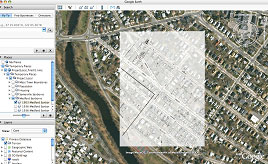
 In the image
above and to the right, for instance, the white rectangle demarcates the boundaries of a Sanborn map of Medford from 1903. The areas outside of the rectangle are images from the 2006 Mass GIS service which have been provided to Google and are displayed to users of the software. As the viewer zooms in, the Google Earth software allows the viewer to
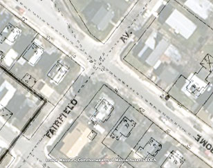
"fade" the map layer so that one can see the 1903 map superimposed over the 2006 map, and thus begin to recognize the streets of today as they existed back then. A closer look reveals street names, property lines, even house numbers. In the map to the left, for example, one can see the intersection of Fairfield and Jerome Streets in West Medford. These streets exist today in the same location as they did in 1903.
In the image
above and to the right, for instance, the white rectangle demarcates the boundaries of a Sanborn map of Medford from 1903. The areas outside of the rectangle are images from the 2006 Mass GIS service which have been provided to Google and are displayed to users of the software. As the viewer zooms in, the Google Earth software allows the viewer to
"fade" the map layer so that one can see the 1903 map superimposed over the 2006 map, and thus begin to recognize the streets of today as they existed back then. A closer look reveals street names, property lines, even house numbers. In the map to the left, for example, one can see the intersection of Fairfield and Jerome Streets in West Medford. These streets exist today in the same location as they did in 1903.
Students can compare the geography of their hometown from one century to the
next and discover how neighborhoods have changed and boundaries have shifted.
The logical next question and the point of departure for possible research is
"why?"